
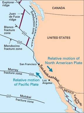
The Image above shows a measurement line between the site of two natural disasters that occurred along the North American Plate, and Pacific Plate boundary. These two points are about 630 miles apart. The Mount Saint Helen's volcano erupted in 1980, and there was an earthquake in Loma Prieta, CA in 1989. Both of these disasters were caused by tectonic plate movements. The Mount Saint Helen's Volcano eruption was caused by a subduction zone along the plate boundaries. The Loma Prieta earthquake occurred because it sits along the San Andreas Fault line which is a transform-fault boundary. The way you can relate these disasters is that they both sit along the Pacific and North American plate boundaries. The tectonic forces and the movement of these plates were the driving force behind both of these disasters. You could say there may not be a connection between the two disasters because they are so far apart from one another, so distance alone would make it hard for them to be related. Also they occurred nearly ten years apart from one another and that is another reason you could say there isn't a connection between the two disasters. You could also say there isn't a connection between the two disasters because one sits along the edge of a subduction zone, and the other along a transform-plate boundary so the tectonic forces that caused the disasters varied from one another. Information Source: http://pubs.usgs.gov/gip/dynamic/understanding.html

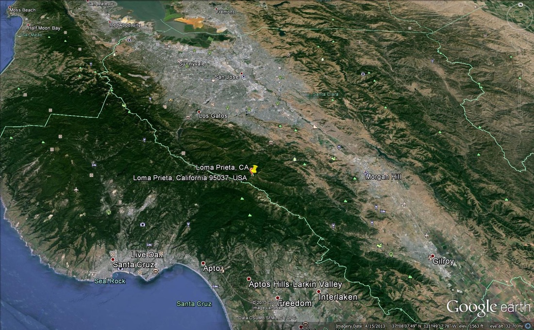
If you look at the image above you can see there aren't any highly populated areas directly around the Mount Saint Helen's volcano. In comparison if you look at the image below there are lots of densely populated areas both to the north and south of where the earthquake occurred. Due to the fact of the differing populations around the two disaster sites you could say that the Loma Prieta earthquake had a larger and more direct impact on humans in the area. With the Mount Saint Helen's eruption though it shot millions of tons of ash into the air that spread several thousand miles and darkened skies. So its effects were felt in other ways and at further distances than the Loma Prieta earthquake. The death count in both disasters were very close to the same, but the number of injuries from the Loma Prieta earthquake were much larger than the injuries suffered from the Mount Saint Helen's eruption. Both of these disasters had a very large impact on humans but vary in the manner or type of the impacts and how they were felt by humans. Information Sources: http://www.livescience.com/27553-mount-st-helens-eruption.html and http://en.wikipedia.org/wiki/1989_Loma_Prieta_earthquake

Above is an image of the Thistle, UT landslide that occurred in 1983. I would have to say that this is the most significant natural disaster that has occurred in my region. The two lines show the area of the slide, the red line shows the distance that it traveled it was about 1 mile. The yellow line shows how wide of an area slid, and it was close to a third of a mile wide area that came down. It was a translational slide, and it was to date the most costly landslide in US history. Many landslides occur in this region. The factors that contribute to this hazard in this region are steep slopes, heavy snowfall in the winters, wildfires that destroy vegetation, rainfall, and even ice wedging to an extent. Below is an image of the Wasatch Front that runs along the Wasatch fault line. The Wasatch fault is active and a major earthquake could hit this region. As you can see in the image below the area along the fault line is densely populated so the human impact of a major earthquake occurring would be huge. The factors that contribute to this hazard is the fact there are so many people living so close to an active fault. It is what is called a normal fault and occurs at a convergent plate boundary. Information Sources: http://geology.utah.gov/online/pdf/pi-40.pdf, http://www.opengeography.org/ch-6-weathering--mass-wasting.html, and http://geology.utah.gov/Surveynotes/geosights/thistle.htm
In the process of creating this page I have learned that we know why most natural disasters occur where they do, and that we know where they are likely to occur in the future. I also have taken notice that humans still continue to live in high risk areas with little to no regard of the risks associated with living in such areas. Even when people know they live in an area where disasters are likely to occur, in most cases they are still unprepared if a disaster were to actually strike. I think before creating this page and looking at the spatial distributions around the area's that these disasters occurred, I had thought that the areas directly around the disaster sites were more densely populated than they actually were. Both occurred in more mountainous areas and there wasn't a large amount of people distributed directly around the sites. I also learned though from looking at the sites and the distribution around them that both disasters still had a huge impact on humans even though they weren't necessarily located at the site of where the disasters occurred. I think as humans we need to try and take it upon ourselves to be more prepared for disasters that may occur in the future. If we can do that, and try not to continue to densely populate areas that are associated with high risks and disasters we can start to lower the human impact felt by these disasters and the huge costs associated with them.
